Damage Prevention Services
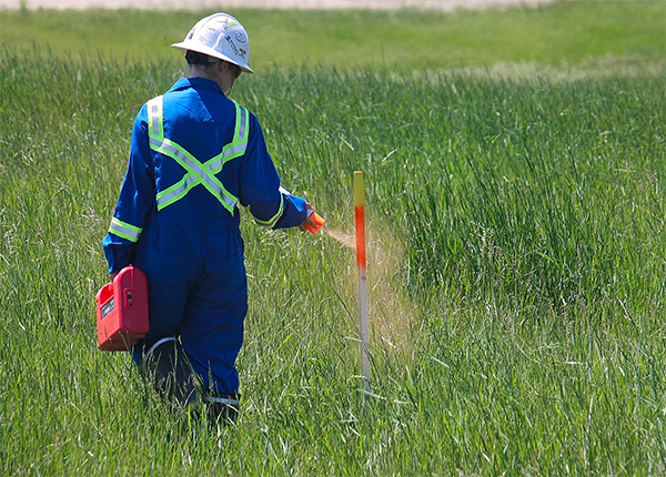
Underground Facility Locating
Using available maps can assist in the efficiency of the locates, and we use any info available, such as existing pipeline databases, survey maps, site plans, as-builts, or historical locate documentation stored in AbsoMap, our proprietary web-based GIS database.
Industry recognized procedures have been adopted and improved to perform comprehensive investigations of all work areas to find all known and unknown locatable underground facilities, clearly mark those facilities, provide industry leading documentation of the results of the investigation, and spatially store that information instantly in our database for future reference.
Different brands of locators have certain strengths and weaknesses, as do different frequencies in different situations. Flexible, adaptable equipment is critical to competently deal with all the different situations that can arise in the field. That is why we continually try the newest locator technology available to assure that we have the best equipment available on the market.
Our common projects are environmental investigations and reclamations, new pipeline, power cable, or cathodic installations, landscaping and commercial development, new well site construction and reclamations, seismic operations, pipeline integrity investigations, road and access construction – any time there is a mechanical ground disturbance in any industry.
GPS Map Creation
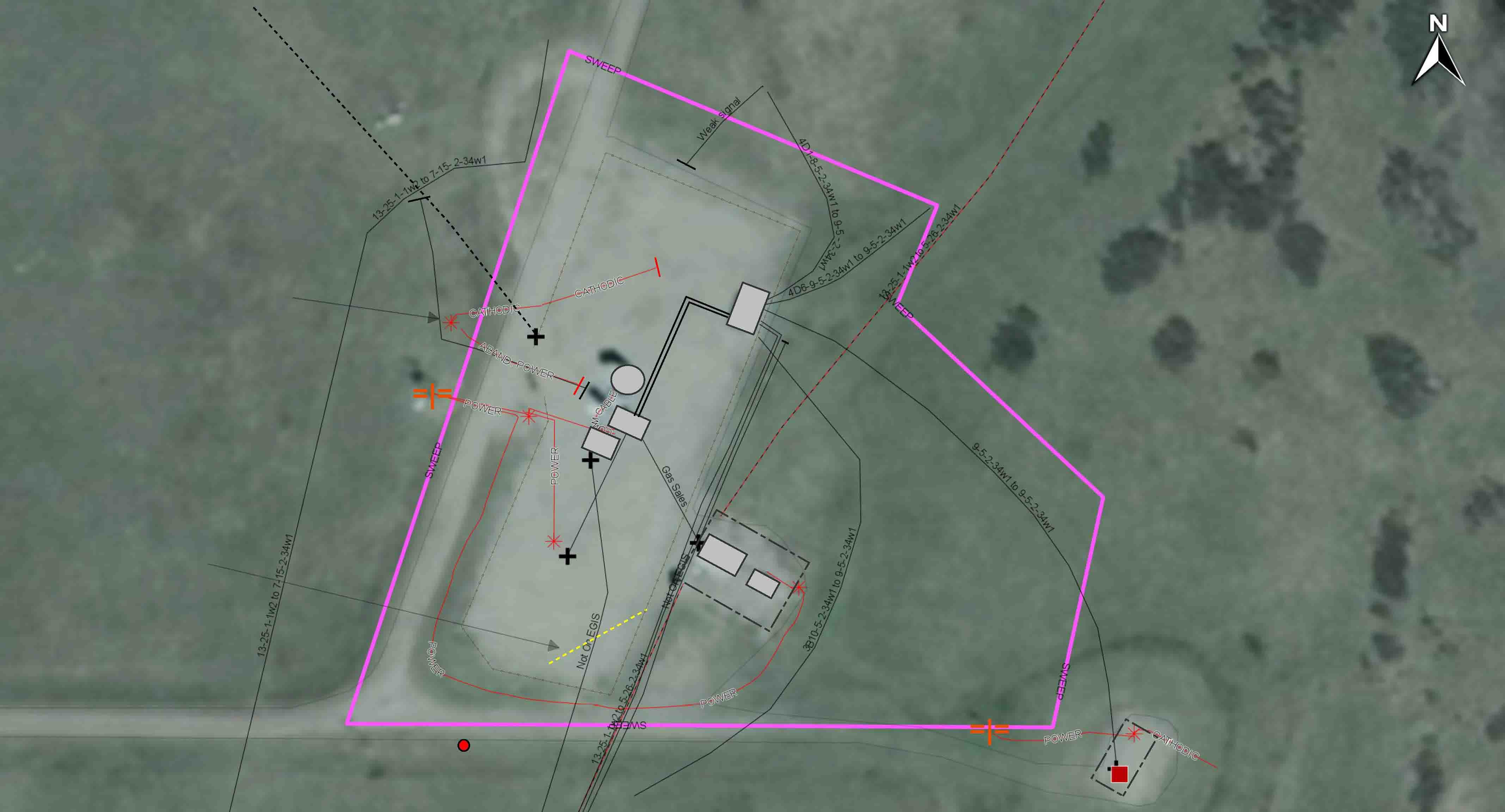
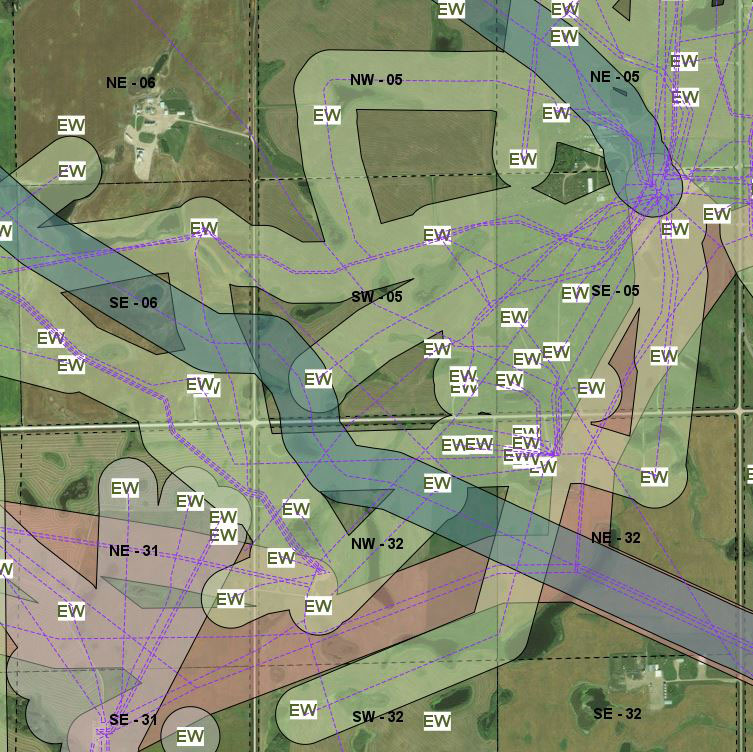
Click here to see pdf map example.
We use map-grade GPS units to gather sub-meter data on the locates we complete.
GPS can be used for many different purposes, including lease boundaries, underground facility mapping, as-built diagrams for commercial sites, area analysis, and environmental impact analysis.
Using our web-based AbsoMap platform to store and access this data, we can use additional data layers to help place our locate results in context with historical locate information, satellite imagery, or provided datasets to help cross-reference our locate results, and provide an above ground context for the underground facilities.
Pipeline analysis for repairs, such as fibreglass inserts in steel flow lines, can help save time and money when major inflection points may be identified before work begins.
Specialty Locating Equipment Services
Marker Balls provides an improved method to electronically mark and locate underground facilities. Unlike other marking devices that use just a single coil, Marker balls contains three orthogonal tuned circuits. When excited by any standard marker locator, these passive circuits produce a uniform, spherical RF field in every direction.
Use the Marker Balls or Discs to mark and find:
- Buried splices and load coils
- Buried service drops
- Pipe ends
- Conduit stubs
- Road crossings
- Cable paths
- Fiber optic facilities
- Manholes under pavement or grade changes
- Snow-covered installations
- Survey points
- Septic installations
- Repair points
- Non-metallic lines
Easily located up to five feet away – provides 25% greater range than traditional 4-inch ball markers. It produces a wider field that is easy to find month or years later, with a signal peak directly above the marker for precise location with inches. This wider field and better range means faster and more reliable locates in any terrain.
No need to stay level when buried – because it produces a spherical field, the Marker Ball does not require any particular orientation when buried. As a result, there’s no need for the Marker Ball to be level in the ground like flat-style electronic markers. Just toss the Marker Ball in the trench or excavation and cover it up with normal backfill. The unique shape also allows it to fit easily into a standard 4-inch trench with no extra digging.
Lightweight, with no hazardous chemicals – contains no floating or moving parts or chemicals eliminating the need for material safety data sheets.
Passive, high reliability design assures many years of service – contains no batteries or active components and the proven high reliability design means these markers will last as long as your buried plant.
It is important to note that marker balls cannot be buried more than 5 feet (1.5m) deep. For applications that require a deeper marker, a full-range marker disc will be required.
Full Range marker discs are ideally suited for marking the location of utilities buried at a deep distance (8 feet or 2.4 meters). Passive full range markers will provide accurate identification of buried power lines, helping to reduce the risk of accidentally excavating other buried facilities. All markers function without the need for an external power source. Their water-resistant polyethylene shells are impervious to minerals, chemicals and the temperature extremes normally found underground.
RODDER SERVICE
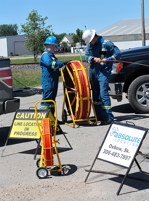
Even with all the technology used to locate underground facilities, there are still situations that involve un-locatable facilities such as fiberglass flowlines with no tracer wires.
For these situations we can use traceable fiberglass duct rodders. These rodders are designed to be used with standard cable and pipe locating equipment to trace the length of the rod, making locating non-conductive facilities up to 10’ depth now a reasonable and easy task.
The traceable fiberglass rodders have a copper wire in the rod that can be energized with a signal transmitter. The locator detects the frequency, allowing the entire buried utility to be traced and marked from above ground.
Please note that in order to use a rodder for locating non-conductive facilities, we require that one side of the facility is opened up and de-pressurized in order to insert the rodder into the facility.
Provincial First Call Management Services
Our investment into improved office capacity and capability has allowed for expansion of Absolute Data Management, our solution for complete Provincial First Call response management.
Absolute Data Management can be your one-stop for all Provincial First Call locate management needs. We can research and build the dataset for submission to the Provincial First Call center to assure effective notification from the call center by using existing datasets from pipeline registries, survey plans, and land titles. We can create necessary files to submit this data on a customer’s behalf. We can create mutually agreeable response criteria based on proximity to customer owned facilities.
Using these criteria, we complete the response on the customer’s behalf, and arrange for locates when required from our qualified team of locators. All documentation is stored and shared with our clients and the involved parties. Joining the Provincial First Call system helps secure our customer’s underground facility network, and ensuring effective communication with everyone in the dig community helps keep the public safe from the underground hazards our industry creates.
Call Before You Dig
Sask 1st Call is a “Call Before You Dig” location screening and notification service for contractors and customers who are planning to dig or excavate. Calling Sask 1st Call will proactively alert the Sask 1st Call subscriber companies of plans to disturb the ground. Sask 1st Call will issue line locate request notifications to subscriber companies to ensure that underground facilities are clearly marked before work starts.
First Call organizations enhance safety to the public and digging community as well as reduce damage and associated costs to underground facilities.
Call 1 (866) 828-4888 or go online to place your 1st Call.